| |
|
If this email is not appearing correctly, please click here to view online. | |
|
|
|
|
|
New Stratigraphy modules and BIM Support
We are pleased to announce that GEO5 2019 is now on general release. This release includes major developments to the Stratigraphy program, site investigation Logs and Cross Sections modules, the BIM functionality and the ability to display structure and/or site locations in Google Maps.
We now offer six standard packages, each package is comprised of several programs, at very attractive prices together with discounted annual maintenance. | |
GEO5 2019 News & Improvements
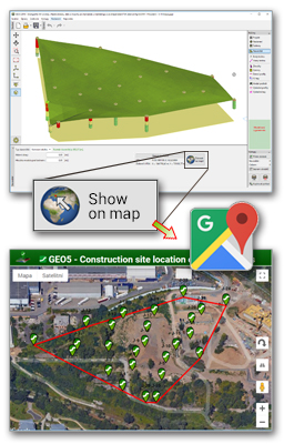
- Input of GPS coordinates with a direct connection to Google Maps
- Export to both IFC and LandXML BIM formats
- Improvements in the Stratigraphy program:
- Import of field test formats including AGS, TXT, UNI, CPT, GEF… and more
- Implementation of specialised geological faults, erosion and landslide models
- Terrain edge definitions
- Optimization supporting very large models
- Faster and improved geological model generation
- For bearing capacity calculations both the Pile CPT and Spread Footing CPT programs can be run from any retaining wall program
- Calculation of both bearing capacity and settlement from pressuremeter tests (PMTs) in the Spread Footing CPT program
- Strip reinforcement in the MSE Wall program
- Definition of horizontal strip and trapezoidal loads for sheeting and retaining wall programs
- And many other additions and improvements...
| | |
New GEO5 Stratigraphy modules
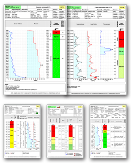
Logs
- Professional site investigation reports including boreholes, CPT, SPT and DMT data
- Comprehensive database of pre-defined templates
- Ability to create user-defined templates and data reports
- Wide range of pattern and color shades now available
- Output of scaled drawings
- Independent of CAD programs
| | |
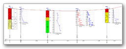
Cross Sections
- Generation of straight and/or polyline cross sections
- Visualization of field tests with soil profiles and users descriptions
- Independent vertical and horizontal drawings scales
- Drawing include both legend and chainage
- Export to DXF and DWG formats
- Construction drawings of generated sections have to be done in CAD programs
| | |
|
|
|
Simplified Pricelist, Cost-optimized Packages
We have altered our pricelist such that both cost of individual programs and packages are easy to follow. We have also introduced six program packages with very attractive maintenance and leasing plans. | |
|
Geology Package
The Geology Package consists of the Stratigraphy program and the Logs and Cross Sections modules. The package is specifically tailored to both site investigation data reporting and geological model generation. The resulting data can be given to geotechnical designers for further subsoil modelling work and it can also be used as input data in other GEO5 programs. | |
|
Cost-effective Fine Maintenance and Program Packages
Your satisfaction with all our products is extremely important to us. Our intention is that our customers always use the current version of our software. For this reason, we have made out maintenance plans more cost-effective and beneficial to you; i.e. when a new program is added to a package, maintained customers get that program for free. | |
|
Require Software for a Single Project? Try our Lease Plans
Do you need our software for a once off specific project? Then take advantage of one of our lease plans. If you like the software, you can convert it to a perpetual license at a very favourable price. | |
|
|
|
|
|
Contact Us.
Should you have any questions or suggestions, please feel free contact us at: hotline@finesoftware.eu. Or call us on +420 233 089 490 from 9:00 to 12:00 and from 13:00 to 16:00 (GMT +1) weekdays. You can also contact Local Dealer in your area. | |
|
|
|
Fine spol. s r.o., Zaverka 12, 169 00 Praha 6.
e-mail: hotline@finesoftware.cz
If you don't wish to receive Fine Newsletter, click Unsubscribe
| | |
| |